
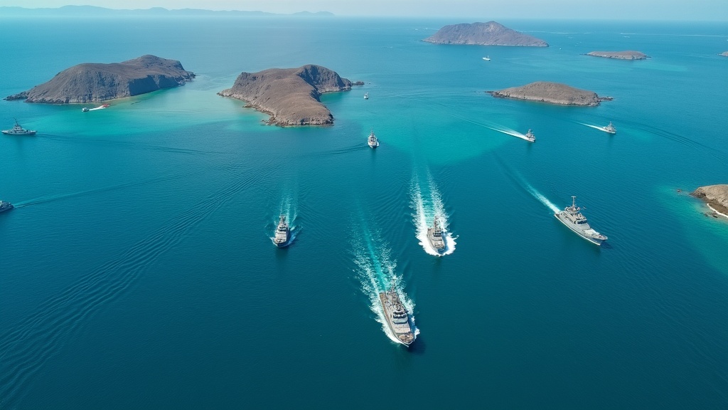
Drone filming in maritime areas has seen a real uptick in popularity, and it’s not hard to understand why. Sweeping ocean views, bustling ports, and untouched coastlines look absolutely eye-catching from the sky.
Yet, when you want to get shots in certain zones, especially those that are restricted or sensitive, things get much more complex. Here’s how you can film drones responsibly (and legally) in restricted maritime areas, including how to sort out permits, negotiate access, pick the right equipment, and nail your shoot with practical tips.
Understanding Restricted Maritime Areas
Not all parts of the water are fair game for drone operators. Various government agencies limit access to safeguard delicate ecosystems, protect national security, conserve marine life, or regulate commercial shipping activities. Examples include naval bases, oil rigs, coastal power stations, certain preservation areas, and global shipping routes.
Restrictions might cover water surfaces only or stretch into the airspace above, which adds another layer of complexity. Different countries have overlapping marine boundaries and airspace rules, so before you film, check both official marine charts and airspace maps. This is the best way to avoid legal headaches. Most countries publish this information, and referencing both is key to making sure your shoot is aboveboard.
For example, if you’re looking to shoot near a busy international port, you should map out the entire area using the latest charts provided by authorities and tune into relevant NOTAMs. This mapping will show not only boundaries but also possible altitudes for safe operation.
Regulation Reasons in These Zones
Why are these places off-limits for drone filming? Mainly for three reasons:
- National Security: Naval bases and military training grounds are high-security areas. Drones can trigger strict responses, even if you’re flying close but not directly above.
- Environmental Protection: Marine reserves and protected zones for wildlife—like turtle nesting beaches or bird sanctuaries—enforce tough no-fly rules to avoid disrupting sensitive species.
- Commercial and Safety Concerns: Drone flights could conflict with port operations, interfere with cargo or oil shipments, or even disrupt offshore rigs. This can pose dangers to both property and lives.
Ignoring the above could mean anything from big fines to having your equipment confiscated, or even getting slapped with criminal charges. You can visit resources like the National Ocean Service and ICAO for a starting point on protected marine areas and related airspace restrictions.
How to Plan a Drone Shoot in Restricted Water Zones
Your success hinges on careful planning. Here’s my step-by-step process:
- Dig Deep With Research: Use current marine charts to spot boundaries and identify restrictions. Drone apps like Airmap or DJI FlySafe can help you find up-to-date airspace advisories for your location.
- Figure Out Who’s in Charge: Identify which agency oversees the area—this can be a port authority, coast guard, environment department, or even an international group if you’re near shared waters.
- Start the Conversation Early: Contact relevant agencies months in advance. Many don’t have dedicated teams for drone requests, so expect some back and forth before you hear a clear answer.
- Make a Thorough Proposal: Submit a detailed flight path, safety steps, drone specifications, insurance policies, and outline your reasons for filming in that specific spot.
Having everything sorted from the get-go not only opens doors but also makes negotiations smoother. In some instances, agencies might ask for background checks or require a representative to supervise your shoot on site.
Permits for Maritime Drone Filming
Permitting in controlled waters isn’t as easy as pulling a permit for a park or public building. Here’s what you might need:
- Flight Authorization: Written approvals typically specify dates, times, flight altitudes, and may cap the duration of your flight.
- Environmental Safeguards: Shooting in eco zones requires proof you won’t disturb wildlife, which could mean stricter flying hours, altitudes, or equipment guidelines.
- Operational Approval: Ports and rigs require specific liability waivers, extra insurance, and sometimes provide you with an on-site escort during filming.
- Security Clearances: Military-run or border control spaces place your plans under closer review and might reserve the right to cancel at the last minute.
Permit costs range widely. While some are a few hundred bucks for a day, others in busier or ultra-secure spots could run you into thousands of dollars. Keep in mind, processing these takes time – weeks, sometimes months, especially if paperwork needs to be reviewed by several agencies.
How to Negotiate Access to Controlled Marine Areas
Negotiating access is far from a tick-box exercise. Here’s how to keep it moving in the right direction:
- Highlight Your Experience: Show off your past projects, especially those backed by other agencies. Certifications and safety training boost your credibility.
- State a Clear Reason: Shoots meant for public awareness, research, or documentary work usually get a warmer reception than those for entertainment or ads. Spell it out clearly to the decision-makers.
- Prove You’re Safe and Responsible: Drill down on how your drone’s features minimize risk. Detail your wildlife avoidance plan and your policies for handling data securely.
- Show Flexibility: Willing to agree to live monitoring or to stay in contact during flights? Stating your openness here can tip things in your favor.
If you’re told “no,” don’t burn bridges. Stay in touch and maintain professionalism for a better shot on your next application.
Guidelines for Legal and Safe Maritime Drone Flight
Operating a drone over open water is risky enough, but maritime rules pile on extra layers:
- Check All the NOTAMs: Look up Notices to Airmen regularly for any temporary hazards or events. It’s common for shipping or naval ops to temporarily close airspace.
- Obey Buffer Spaces: Many authorities demand you keep far away from specific infrastructure or animal colonies—sometimes well outside your original flight plan.
- Always Keep Eyes on Your Drone: Over water, losing sight raises the risk of connections dropping or losing the drone. Use a spotter if you can.
- Prep for Emergencies: Pinpoint recovery and safe-landing spots. Carry extra floats or line-recovery tools to grab your drone if things go sideways.
- Mind the Height: Generally, flights are capped at 120 meters, but marine restricted zones might force you down even lower.
One slip-up on a rule or buffer could lose more than a permit. Some agencies may even monitor by patrol boat or electronic means, so sticking to every rule is in your best interest.
Maritime Filming Equipment Essentials
Shooting at sea is a big step up from a casual park flight. Salt, wind, and humidity are brutal on gear. Make sure to prep with:
- Waterproof Drones: Brands like Swellpro SplashDrone or DJI Matrice with custom waterproofing handle the elements well.
- Extra Props and Batteries: Batteries can drain fast and saltwater eats into gear—backups cut downtime if anything fails.
- ND Filters and Shade Hoods: Sun glare is extreme out on the water. ND filters really make your footage pop.
- Signal Boosters: Water reflecting the signal can mess with control or video feeds, so an antenna boost adds reliability.
- GPS Trackers: A floating tracker upps your odds of finding your drone if there’s a breakdown.
Test everything from the coast first. Glitches are easier to fix onshore, and you want to know your gear works before heading out to open water.
On-the-Ground Filming Tips for Ocean Zones
Filming in controlled sea spaces calls for smart moves:
- Map Your Flight Plan: Program your path in advance so you don’t cross into forbidden zones while in the air.
- Carry Permits and IDs: Both digital and physical copies—authorities could show up on boats or at the dock to check your paperwork.
- Keep Up With Real-Time Weather: Maritime weather flips fast—be ready to pause or stop if rain, wind, or mist intensifies.
- Minimize Animal Disturbance: Early or later flights disrupt marine life less, especially during mating or nesting times.
A second set of eyes is valuable—an observer can spot new hazards or wildlife, watching for anything that might force you to pause or land quickly.
Post-Filming: Data Management and Exiting Procedures
Many controlled spots require a formal sign-off before you leave. Here’s what to watch for:
- Footage Review: Agencies might need to scan your footage or even request a handover of SD cards at the end of your shoot.
- Usage Limits: Sometimes, you’ll be told where and how you can publish or export your shots, or you’ll need to blur out sensitive infrastructure and vessels.
- Wrap-Up Reports: Some agencies may require a shoot summary, as well as credits listing them for access on any published media.
Keeping data safe and honoring any publishing conditions helps foster ongoing trust. Doing things by the book ups your odds for next time.
Example Experience: Negotiating Marine Park Access
I once worked on a nature documentary that needed aerial footage from a highly protected marine park—well known for rare sea turtle nesting. The first reply from the park authorities was a flat-out no to drones. However, by sending a detailed, science-focused plan, providing proof of safe shooting history, and agreeing to fly under close supervision, we secured special permission. We had a park biologist with us at all times, stuck to strict altitude caps, and agreed to on-the-spot footage review. It wasn’t easy, but flexibility, openness, and patience made it happen—plus strong networking for the future!
FAQs: Drone Filming in Restricted Maritime Zones
Can I fly my drone near any coastline or port?
Not every stretch of coast or port is accessible for drone operation. Most busy shipping routes, naval bases, and wildlife reserves enforce permit-only or total bans on drone flights. Check both airspace and marine rules before setting out.
How long does it take to get a permit?
It often takes several weeks or months, especially if you’re dealing with multiple agencies or international borders. Begin the application early and submit complete, organized paperwork to fast-track the process.
Does bad weather delay approval?
Absolutely. If conditions are considered unsafe or there’s expected wildlife activity, agencies might delay or restrict permits to specific windows. Always stay in contact in the run-up to your shoot.
If my application is denied, can I try again?
Often you can. If you update your proposal to show increased safety, pinpoint your goals, or minimize impact, your application might get accepted later on. Keep communication open and friendly for best results.
Wrapping Up
Being able to film with a drone in restricted maritime places takes more than piloting expertise. Getting the right info, patiently negotiating for approval, following every rule to the letter, and treating authorities with respect make all the difference. Not every shoot gets a green light, but with solid prep and professionalism, you’re more likely to score the permits and capture truly unique footage. Responsible drone use helps everyone appreciate these remarkable places and ensures they can stay protected for future generations.


It makes sense that flying drones in restricted maritime areas are not allowed and we should respect that.
You’re right, thorough explanation with basis on why you need to do those shots are really important.
Those drone shots really are amazing if needed in informative videos.
They make the story more relevant and exciting.
Marita
Thanks so much, Marita—totally agree with you. Respecting restricted maritime zones is crucial, both for safety and for protecting sensitive environments or operations. It’s great to hear you value the importance of having a clear purpose behind drone usage too—it really does make a difference.
And yes, when used thoughtfully, drone shots can elevate a video in a big way. They add context, scale, and visual impact that’s hard to match with ground-level footage. The key is always to strike that balance between storytelling and responsibility.
Appreciate your thoughtful input as always!
I would have loved to see this article before taking my son out behind the boat wakeboarding.
We thought it would be great to get some high rised images and sent the drone up with out batting an eye.
With in minutes we were getting in trouble. We are now looking for information around where we can find this and it was great to stumble accross this blog.
Thanks for sharing your experience! It’s amazing how easy it is to get caught up in the excitement and forget that there are rules around flying, especially near boats and people. I’m glad you found the blog helpful—better late than never! Hopefully, the resources we’ve shared will help you find clear guidance on safe and legal drone use so you can capture those awesome wakeboarding moments without any trouble next time.
This is a solid reminder that flying drones over open water isn’t something to take lightly. Between checking NOTAMs, respecting buffer zones, and having a recovery plan, there’s a lot more to think about than just getting the perfect shot. The gear recommendations are on point too—waterproofing, signal boosters, and trackers can make all the difference when conditions get tough. Anyone serious about maritime drone work should take this seriously and treat it as part of the flight, not just prep. It’s not just about protecting your drone—it’s about doing things responsibly, legally, and with respect for the environment you’re flying in.
Absolutely—well said. Over open water, the margin for error is razor-thin, so planning and precaution are just as critical as piloting skill. I’m with you on treating safety, legality, and environmental respect as part of the flight itself—it’s all one package. The perfect shot is only worth it if you can get it without risking people, wildlife, or your drone. And yes, those trackers and waterproofing upgrades have saved me more than once when the weather turned faster than forecast.
I enjoyed your post on flying Drones over restricted maritime areas. I had no ideas permits were so much! I will say, I believe as a tax payer, if the pictures are free for the public to view and use there should not be a fee that high. I also figured it would be difficult to get into restricted areas. If they don’t want civilian drones in the restricted areas then why don’t they share the photos with the public?
I’m glad you enjoyed the post! You make a great point—if the public is funding these operations through taxes, it seems reasonable to expect more open access to imagery, especially when it comes to non-sensitive content. The high permit costs are often justified as covering administrative processes, safety oversight, and security concerns, but it can definitely feel excessive for individuals who just want to contribute to public knowledge. As for sharing photos, many agencies do release imagery, but they tend to be selective due to national security or environmental protection policies. It’s a tricky balance between public transparency and safeguarding sensitive areas, and that’s where the debate really lies.
Hey, Andrejs!
Thanks for sharing this topic! Love the imagery at the start, showing basic things about drone filming maritime areas
Honestly, I would say many times I dislike drones flying around and disturbing my peace at nice, natural locations. It was not nature nature-protected area, still, pretty often I dislike it when I am near the sea. At the same time, I should not complain too much – not many here are filming with drones or flying drones around in general
For sure, it can get amazing videos like that, videos you cannot get otherwise. Thanks for answering all those questions that people were looking to be answered! If it is done properly, no problem at all. I think we all would like to see those beautiful videos. Thanks for sharing your experience with a nature documentary that needed aerial footage from a highly protected marine park! Nice to hear it worked out in the end, but it shows we all need a really good plan, strategy and patience
Thanks!
Best regards, Linda Mo
Hey Linda,
Thanks a lot for your thoughtful comment! I completely understand your perspective—drones can definitely feel disruptive in peaceful natural spots, especially when they’re not flown responsibly. That’s why I think it’s so important to balance the respect for the environment and people around us with the creative opportunities drones bring.
You’re right—when used carefully, drones can capture perspectives that simply wouldn’t be possible otherwise, and in cases like the documentary I mentioned, it really shows the value of proper planning and permissions. I’m glad you highlighted the importance of strategy and patience—those really make all the difference in making drone filming a positive experience for everyone involved.
Appreciate your kind words and reflections—it’s always great to hear different viewpoints!
Best,
Andrejs
This was such a thorough and eye-opening guide! I really appreciate how you highlighted not just the technical side of drone filming, but also the legal, environmental, and safety considerations. The example with the marine park really drove home how patience and professionalism can open doors that initially seem closed.
I’m curious—do you think advances in AI-powered flight control and automated geo-fencing will eventually make it easier (and safer) for filmmakers to navigate these restricted maritime zones without risking violations?
Thank you so much—I’m glad you found it helpful! That’s a really insightful question. I do think AI-powered flight control and smarter geo-fencing will play a big role in making operations safer and more compliant, especially in sensitive maritime zones. The challenge, though, is that regulations often evolve more slowly than technology. Even if the tools make it technically safer to fly, filmmakers will still need to go through the proper approval processes to ensure their work respects both the law and the environment. Ideally, AI could become a bridge—helping pilots avoid mistakes while also giving regulators more confidence to grant access in places that are currently off-limits.